Community Corner
Excessive Heat Warning Now in Effect for Fridley
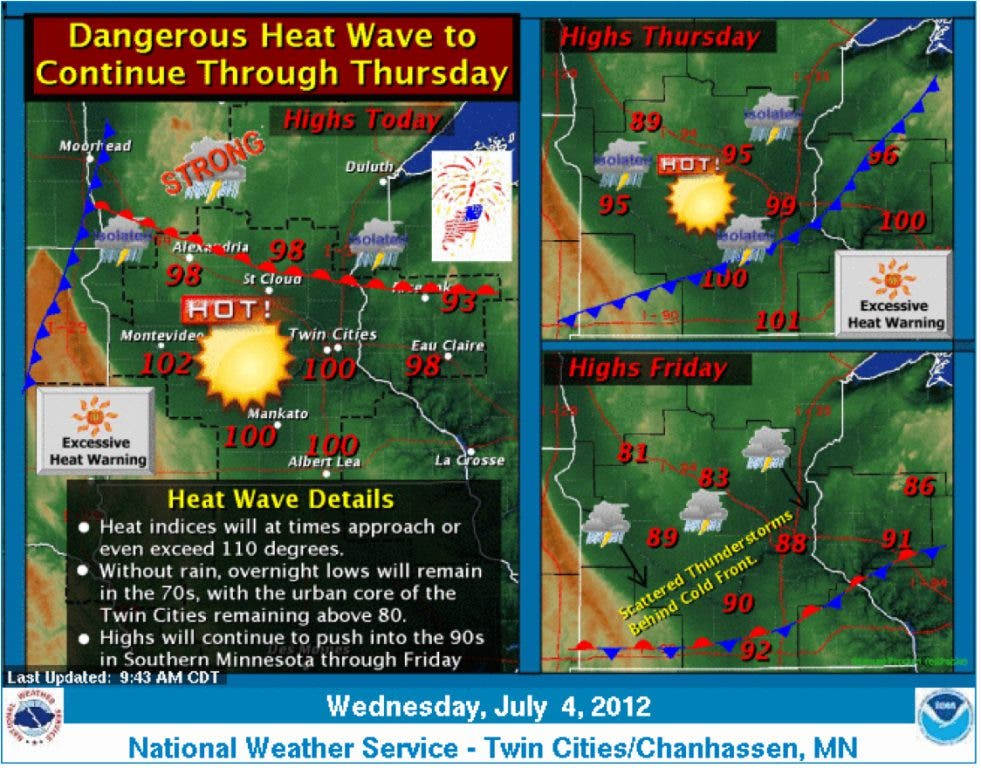
Forget advisories: Fridley, Anoka County and most of central and southern MN are now under an excessive-heat warning through Thursday night.

are out the window—with any luck, a window with an AC unit.
Fridley and most of central and southern Minnesota is now under an excessive-heat warning, according to the National Weather Service. (See the difference between warnings and advisories below.)
The warning last through Thursday at 10 p.m. Take it extremely easy, stay cool and keep drinking.
Find out what's happening in Fridleywith free, real-time updates from Patch.
Here is weather information the National Weather Service issued at 12:10 p.m. Wednesday, along with advice on staying safe in the heat wave.
AN EXCESSIVE HEAT WARNING REMAINS IN EFFECT FOR ALL OF CENTRAL AND SOUTHERN MINNESOTA AND WEST CENTRAL WISCONSIN THROUGH 10 PM THURSDAY EVENING.
Find out what's happening in Fridleywith free, real-time updates from Patch.
FOR TODAY...NEAR RECORD HIGH TEMPERATURES ARE EXPECTED ACROSS THE ENTIRE AREA...
WITH AFTERNOON HIGHS REACHING THE MID 90S TO LOWER 100S. THESE TEMPERATURES COMBINED WITH DEWPOINTS IN THE LOWER TO MID 70S WILL RESULT IN HEAT INDEX VALUES REACHING THE 105 TO 112 DEGREE RANGE DURING THE AFTERNOON.
LOWS ARE EXPECTED TO REMAIN IN THE 70S AGAIN TONIGHT WITH LOW TEMPERATURES PROBABLY NOT DIPPING BELOW 80 IN THE TWIN CITIES.
ANOTHER HOT DAY IS ON TAP FOR THURSDAY... BUT A WEAK COOL FRONT MOVING ACROSS THE GOPHER STATE MAY BRING A BIT OF RELIEF TO CENTRAL MINNESOTA. THIS COMBINATION OF VERY HOT DAYTIME CONDITIONS WITH VERY WARM OVERNIGHT LOWS WILL RESULT IN VERY DANGEROUS HEAT CONDITIONS.
THOSE IN BUILDINGS WITHOUT AIR CONDITIONING OR WORKING OUTSIDE SHOULD USE EXTREME CAUTION AND DRINK PLENTY FLUIDS AND SEEK RELIEF WITH AIR CONDITIONED ENVIRONMENTS WHEN POSSIBLE.
TEMPERATURE...HIGHS WILL RANGE FROM 94 TO NEAR 103...AND DEW POINTS WILL BE ABOVE 70. THIS WILL RESULT IN AFTERNOON HEAT INDEX VALUES RANGING FROM 105 TO 112 TODAY. A BIT OF MODERATION IS EXPECTED IN CENTRAL MINNESOTA ON THURSDAY...
BUT THE REMAINDER OF THE AREA WILL AGAIN SEE AN AFTERNOON HEAT INDEX ABOVE 105 DEGREES. IF NO THUNDERSTORMS OCCUR...OVERNIGHT LOWS WILL REMAIN VERY WARM...WITH TEMPERATURES ONLY EXPECTED TO FALL BACK TO BETWEEN 72 AND 79 DEGREES AWAY FROM THE TWIN CITIES METRO...AND AROUND 80 WITHIN THE METRO.
IMPACTS...THE HOT AND HUMID CONDITIONS WILL LEAD TO A HEIGHTENED RISK OF HEAT RELATED STRESS AND ILLNESS. IF YOU MUST BE OUTSIDE...BE SURE TO REMAIN HYDRATED AND TAKE MULTIPLE BREAKS WITHIN AIR CONDITIONED ENVIRONMENTS. PRECAUTIONARY/PREPAREDNESS ACTIONS...
TO REDUCE RISK DURING OUTDOOR WORK...SCHEDULE FREQUENT REST BREAKS IN SHADED OR AIR CONDITIONED ENVIRONMENTS. ANYONE OVERCOME BY HEAT SHOULD BE MOVED TO A COOL AND SHADED LOCATION. HEAT STROKE IS AN EMERGENCY...CALL 9 1 1. TAKE EXTRA PRECAUTIONS IF YOU WORK OR SPEND TIME OUTSIDE. WHEN POSSIBLE...
RESCHEDULE STRENUOUS ACTIVITIES TO EARLY MORNING OR EVENING. KNOW THE SIGNS AND SYMPTOMS OF HEAT EXHAUSTION AND HEAT STROKE. WEAR LIGHT WEIGHT AND LOOSE FITTING CLOTHING WHEN POSSIBLE AND DRINK PLENTY OF WATER.
AN EXCESSIVE HEAT WARNING MEANS THAT A PROLONGED PERIOD OF DANGEROUSLY HOT TEMPERATURES WILL OCCUR. THE COMBINATION OF HOT TEMPERATURES AND HIGH HUMIDITY WILL COMBINE TO CREATE A DANGEROUS SITUATION IN WHICH HEAT ILLNESSES ARE LIKELY.
DRINK PLENTY OF FLUIDS...STAY IN AN AIR-CONDITIONED ROOM...STAY OUT OF THE SUN... AND CHECK UP ON RELATIVES AND NEIGHBORS.
Here are some definitions that the National Weather Service offers:
- Excessive Heat Warning Issued within 12 hours of the onset of the following criteria: heat index of at least 105°F for more than 3 hours per day for 2 consecutive days, or heat index more than 115°F for any period of time.
- Advisory Highlights special weather conditions that are less serious than a warning. They are for events that may cause significant inconvenience, and if caution is not exercised, it could lead to situations that may threaten life and/or property.
- Excessive Heat Watch Issued by the National Weather Service when heat indices in excess of 105ºF (41ºC) during the day combined with nighttime low temperatures of 80ºF (27ºC) or higher are forecast to occur for two consecutive days.
- Excessive Heat Excessive heat occurs from a combination of high temperatures (significantly above normal) and high humidities. At certain levels, the human body cannot maintain proper internal temperatures and may experience heat stroke. The "Heat Index" is a measure of the effect of the combined elements on the body.
Get more local news delivered straight to your inbox. Sign up for free Patch newsletters and alerts.


